Results 1-3 of 3
<<< Previous 1 Next >>>
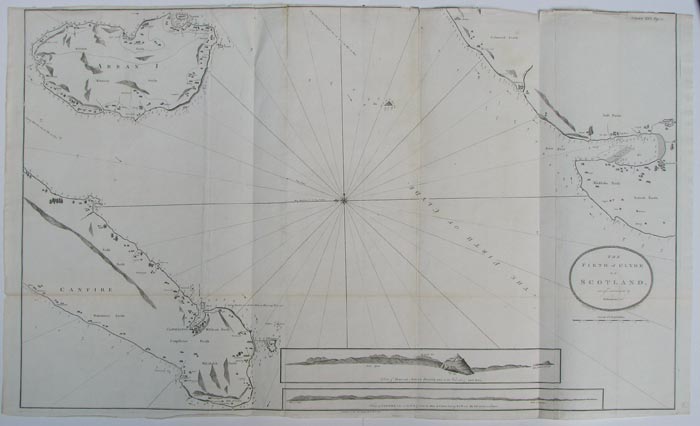
The Firth of Clyde in Scotland, surveyed and navigated by M.Mackenzie Sen.r.
Engrav'd by G.Terry, 62. Pater noster Row.
Publish'd as the Act directs Jan.y 23.d 1776.
Engraved sea chart. Three sheets conjoined, total 780 x 1270mm, 30¾ x 50". With original binding folds, top edge chipped.
Orientated with north to the left, this chart shows the outer reaches of the Firth of Clyde: Stranraer, Loch Ryan and the northern tip of the Rhinns of Galloway, Arran and the southern tip of the Kintyre peninsula. With two coastal profiles. Murdoch Mackenzie (1712-1797), born on Orkney, was employed by the Royal Navy to chart waters of the west of Scotland, Ireland and Wales. After 20 years' work the resulting charts were published by Mackenzie himself as 'A maratim survey of Ireland and the west of Great Britain', in two large folio volumes. The charts of the nororiously treacherous waters of western Scotland remained the best available for over a century.
[Ref: 10004] £220.00
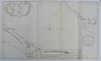
The North Coast of the Isle of Man; with the Bay of Luce in Scotland; surveyed and navigated by M.Mackenzie Sen.r.
Publish'd as the Act directs Dec.r 23.d 1775.
Engraved sea chart. Three sheets conjoined, total 720 x 1280mm, 28¾ x 50½". With original binding folds.
Orientated with north to the left, this chart shows Peel and Ramsey on the Isle of Man, the Rhinns of Galloway south of Port Patrick, Glenluce and Whithorn (here 'Whitehoren'), site of the first recorded Christian church in Scotland. With three coastal profiles. Murdoch Mackenzie (1712-1797), born on Orkney, was employed by the Royal Navy to chart waters of the west of Scotland, Ireland and Wales. After 20 years' work the resulting charts were published by Mackenzie himself as 'A maratim survey of Ireland and the west of Great Britain', in two large folio volumes. The charts of the nororiously treacherous waters of western Scotland remained the best available for over a century.
[Ref: 10003] £280.00
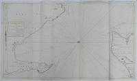
The Channel between Sky I. and the Lewis; surveyed and navigated by M.Mackenzie sen.r.
Published as the Act directs Jan.y 30th 1776.
Engraved sea chart. Two sheets conjoined, total 680 x 1020mm, 26¾ x 40", With original binding folds.
A sea chart of the passageway between Skye and Lewis, important as the main route to northern Scotland within the Outer Hebrides. Orientated with north to the left. Murdoch Mackenzie (1712-1797), born on Orkney, was employed by the Royal Navy to chart waters of the west of Scotland, Ireland and Wales. After 20 years' work the resulting charts were published by Mackenzie himself as 'A maratim survey of Ireland and the west of Great Britain', in two large folio volumes. The charts of the nororiously treacherous waters of western Scotland remained the best available for over a century.
[Ref: 9994] £260.00
<<< Previous 1 Next >>>